|
NEVERSINK STREAM MANAGEMENT PLAN RECOMMENDATIONS
Stream Glossary
East Branch Neversink River
East Branch Neversink River Management Unit 1
Post Flood Addendum East Branch Neversink MU1
East Branch Neversink River Management Unit 2
Post Flood Addendum East Branch Neversink MU2
East Branch Neversink River Management Unit 3
Post Flood Addendum East Branch Neversink MU3
East Branch Neversink River Management Unit 4
Post Flood Addendum East Branch Neversink MU4
East Branch Neversink River Management Unit 5
Post Flood Addendum East Branch Neversink MU5
East Branch Neversink River Management Unit 6
Post Flood Addendum East Branch Neversink MU6
East Branch Neversink River Management Unit 7
[MU7 has no post flood addendum]
East Branch Neversink River Management Unit 8
Post Flood Addendum East Branch Neversink MU8
East Branch Neversink River Management Unit 9
Post Flood Addendum East Branch Neversink MU9
East Branch Neversink River Management Unit 10
Post Flood Addendum East Branch Neversink MU10
East Branch Neversink River Management Unit 11
Post Flood Addendum East Branch Neversink MU11
East Branch Neversink River Management Unit 12
Post Flood Addendum East Branch Neversink MU12
East Branch Neversink River Management Unit 13
Post Flood Addendum East Branch Neversink MU13
East Branch Neversink River Management Unit 14
Post Flood Addendum East Branch Neversink MU14
East Branch Neversink River Management Unit 15
Post Flood Addendum East Branch Neversink MU15
East Branch Neversink River Management Unit 16
Post Flood Addendum East Branch Neversink MU16
Main Branch Neversink River
Main Branch Neversink River Management Unit 1
Main Branch Neversink River Management Unit 2
Main Branch Neversink River Management Unit 3
Main Branch Neversink River Management Unit 4
Main Branch Neversink River Management Unit 5
Main Branch Neversink River Management Unit 6
Main Branch Neversink River Management Unit 7
Main Branch Neversink River Management Unit 8
Post Flood Addendum Main Branch Neversink MU8
Main Branch Neversink River Management Unit 9
Post Flood Addendum Main Branch Neversink MU9
Main Branch Neversink River Management Unit 10
Post Flood Addendum Main Branch Neversink MU10
West Branch Neversink River
West Branch Neversink River Management Unit 1
West Branch Neversink River Management Unit 2
Post Flood Addendum Neversink River MU2
West Branch Neversink River Management Unit 3
West Branch Neversink River Management Unit 4
West Branch Neversink River Management Unit 5
West Branch Neversink River Management Unit 6
West Branch Neversink River Management Unit 7
West Branch Neversink River Management Unit 8
West Branch Neversink River Management Unit 9
West Branch Neversink River Management Unit 10
West Branch Neversink River Management Unit 11
West Branch Neversink River Management Unit 12
West Branch Neversink River Management Unit 13
West Branch Neversink River Management Unit 14
West Branch Neversink River Management Unit 15
West Branch Neversink River Management Unit 16
West Branch Neversink River Management Unit 17
Introduction
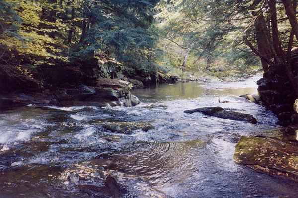
Encompassing approximately ninety-three square miles, the Neversink
Reservoir watershed is located in Ulster and Sullivan Counties,
NY. The Neversink River, including both its East and West Branches,
drains seventy-one square miles; twenty-two square miles drain
directly into the Neversink Reservoir through two dozen small
tributaries. The Neversink watershed lies predominantly in the
Towns of Denning and Neversink, with a small portion of its headwaters
in the Town of Shandaken, and very small portions of the Towns
of Liberty and Fallsburg draining directly into the reservoir.
The mainstem divides approximately 8.7 kilometers (5.4 miles)
upstream of the Neversink Resevoir into two major Branches, East
and West; all three of these mainstems have long narrow watersheds
running northeast to southwest. This drainage pattern is controlled
by steep topography, formed in large part during the last period
of glacial activity. Streams in the Neversink valley are primarily
perennial streams, that is, they flow year-round except in smaller
headwater streams or in extreme drought conditions. Mean annual
precipitation in the watershed ranges from 1220 to 1410 mm (48-55”).
The watershed is largely forested, and road density, impervious
cover and percentage of the watershed with buildable soil conditions
are all relatively low for the Catskills, resulting in low development
pressures and high raw water quality. The primary water quality
impacts are from atmospheric deposition and management of road
embankments and crossings.
In the next few years, the New York City Department of Environmental
Protection (NYCDEP) will be reaching out to stakeholders and natural
resource managers responsible for the Neversink watershed to develop
a comprehensive Stream Management Plan. Similar plans have been
developed for other sub-basins and basins in the Catskills (see
below). These Plans are multi-objective, and are intended to promote
the coordination of resource management and education and outreach
on a broad range of management issues, including emergency response
to flooding and long-term protection of ecological integrity.
Maps
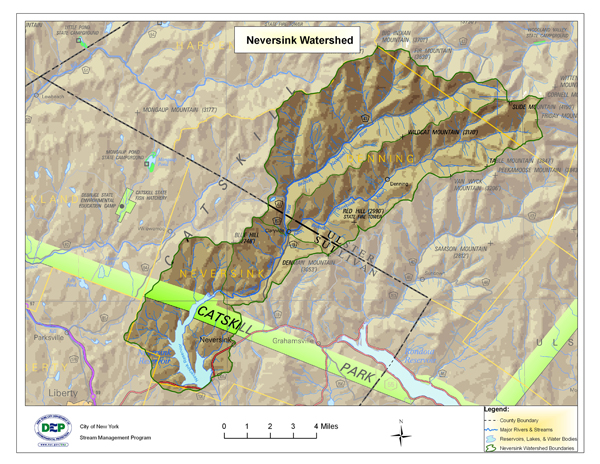
Click
here for a larger view of the above map
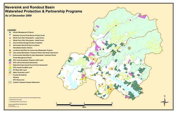
Click
here for a larger view of the above map
USGS Gage Links
The United States Geological Survey (USGS) maintains 6 continuous-recording
stream gages in the Neversink River watershed above the Reservoir.
These gages measure the stage, or height, of the water surface
at a specific location, updating the measurement every 15 minutes.
Click on the Station ID number of your gage of interest to receive
real-time water surface data from USGS.
| Station
ID |
Station
Name |
Drainage
Area (Mi_) |
Current
Period of Record |
| 0143400680 |
E BR NEVERSINK R NORTHEAST OF DENNING |
8.93 |
Oct 1990 - May 2013 |
| 01434017 |
EAST BR NEVERSINK RIVER NR CLARYVILLE |
22.9 |
Feb 1937 - present |
| 01434021 |
W BR NEVERSINK R AT WINNISOOK L NR FROST VALLEY |
0.77 |
Jan 1991 - May 2013 |
| 01434025 |
BISCUIT BK ABOVE PIGEON BK AT FROST VALLEY |
3.72 |
Jun 1983 - present |
| 01434498 |
WEST BRANCH NEVERSINK R AT CLARYVILLE |
33.8 |
Jul 1991 - present |
| 01435000 |
NEVERSINK RIVER NEAR CLARYVILLE |
66.6 |
Jul 1951 - present |
Demonstration Restoration Projects
No Demonstration Restoration Projects currently exist.
Stream Management Plans
Click
here for Intro and links to Stream Management Plans
Basin Specific Studies and Other Resources
THE SOURCE, February 2011 Newsletter of the Rondout/Neversink Stream Management Program
Spread the Word, Not the Weed: Knotweed Brochure
Managing Large Woody Debris in Sullivan County, NY
Rondout Basin Action Plan(s)
Rondout/Neversink Stream Management Program Action Plan 2010 - 2012
Rondout/Neversink Stream Management Program Action Plan 2013 - 2015
Contact Information
Karen Rauter
Stream Program Coordinator
Sullivan County Soil & Water Conservation District
P.O. Box 256, 273 Main Street
Grahamsville, NY 12470
Phone: (845) 985-2581
KarenRauter@RondoutNeversinkStreams.org
Mark Vian
Project Manager
NYCDEP
71 Smith Ave
Kingston, NY 12491
Phone: (845) 340-7851
Fax: (845) 338-1367
mvian@dep.nyc.gov
|