NAVIGATIONPROJECT MAP
GCSWCD
SCHOHARIE CREEK
STREAM GAGES
WEST KILL
EAST KILL
MANOR KILL
BATAVIA KILL
Schoharie Creek
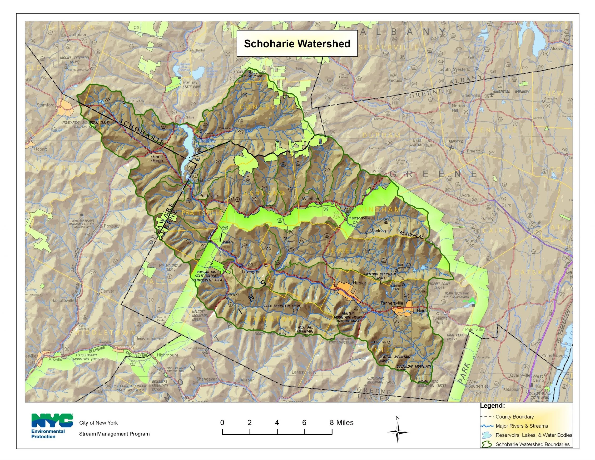
Encompassing approximately 315 square miles, the Schoharie Reservoir watershed, is located primarily in Greene County, NY. The Schoharie Creek drains eight Greene County municipalities, not including direct drainage to the reservoir, including large sections of the Towns of Prattsville, Lexington, Jewett, Hunter, Ashland, Windham and the Villages of Hunter and Tannersville. Traveling from east (Hunter) to west (Prattsville), the primary tributaries that drain into the Schoharie Creek are the East Kill, West Kill, Little West Kill, Batavia Kill, Huntersfield Creek, Johnson Hollow Brook, and directly into the reservoir the Bear Kill and Manor Kill. The major streams within the Schoharie watershed tend to have long, narrow watersheds running east to west. This drainage pattern is controlled by the steep topography, formed in large part during the last period of glacial activity. Streams in the Schoharie valley are primarily perennial streams, that is, they flow year-round except in smaller headwater streams or in extreme drought conditions.
Greene County Soil & Water Conservation District
The Greene County Soil & Water Conservation District (GCSWCD) is a county-level, political subdivision of New York State dedicated to the best management of natural resources. Located in southeastern NY, Greene County is home to the northernmost Catskill high peaks and is bordered on the east by the Hudson River. The District has been in existence since 1961, and was initially formed to facilitate the implementation of a major federal flood control project in the Town of Windham. Since its inception, the GCSWCD has developed a diverse conservation program to address local needs, and assist landowners, local municipalities as well as state and federal agencies in their conservation efforts.
Stream Management
-
GCSWCD • Joel DuBois (518) 622-3620
NYC DEP Stream Management • Dave Burns: 845-340-7850
-
GCSWCD and NYCDEP have an intergovernmental agreement to fund stream management plan implementation projects and provide stream-related technical assistance within the Schoharie Reservoir watershed. One component of the agreement is the Stream Management Implementation Program (SMIP). The SMIP is a collaborative program between GCSWCD, DEP, and municipalities within the Schoharie Reservoir watershed. This program offers funding for government agencies, streamside landowners, and 501(c)(3) organizations involved in stream stewardship that fosters water quality protection and enhancement.
Information on eligible applicants and projects can be found here: https://www.gcswcd.com/schoharie-reservoir-watershed/swsmp/smip
-
Schoharie Watershed Advisory Committee
The Schoharie Watershed Advisory Committee allows for collaboration on watershed efforts that benefit both water quality and the watershed communities. All watershed towns within Greene County have adopted Stream Management Plans and Stream Stewardship Principles, signed Memoranda of Understanding with the Greene County Soil & Water Conservation District (GCSWCD) and have assigned representatives to the Schoharie Watershed Advisory Committee.
Schoharie Watershed Advisory Committee Membership
There are 15 appointed representatives on the SWAC, including a representative from each of the eleven municipalities in the watershed, a highway/infrastructure subcommittee representative, an education/outreach subcommittee representative, a representative from a recreation/habitat subcommittee and a Greene County Legislator.
Advisory members include non-profit organizations working in the basin, regulatory agencies, NYCDEP and County Soil & Water Conservation Districts and Planning Departments. Advisory members are available to assist the Committee as needed and serve as potential project sponsors. GCSWCD provides the primary staffing for SWAC. The SWAC meets twice annually, and meetings are open to the public.
-
Throughout the development, adoption and implementation of these plans there are many opportunities for public involvement.
These include: attending public meetings, participating in focus group discussions, becoming familiar with plan contents, assisting on working groups, participating in workshops and activities like stream clean-ups or streamside plantings, supporting town adoption of stream management plans, and communicating interest in implementing plan recommendation.
-
Action Plan to Guide Stream Management Plan Implementation in the Schoharie Watershed, 2023-2025
Action Plan to Guide Stream Management Plan Implementation in the Schoharie Watershed, 2022-2024
-
Batavia Kill: Ashland Connector Stream Restoration Project Report
Batavia Kill: Brandywine Restoration Project Implementation and Monitoring Report
Batavia Kill: Maier Farm Restoration Project Implementation and Monitoring Report
West Kill: Westkill Stream Restoration Demonstration Project Report
Schoharie Creek: County Route 13 Undersized Culvert Replacement
Schoharie Creek: Schoharie Creek Embankment Repair at Schoharie Street
-
-
Project Map
Project Maps provide information on a selection of full channel stream restoration, stormwater and infrastructure, riparian buffer restoration, streambank stabilization, and floodplain restoration projects that have been constructed to meet multiple objectives including: infrastructure protection, improved flood conveyance and sediment transport, improved fish habitat, and improved riparian functions.
Schoharie Projects Webmap
Stream projects are one component of the NYCDEP SMP). The primary goals of stream management projects include water quality improvement through the reduction of bed or bank erosion and the associated turbidity and other pollutants, infrastructure and/or property protection (flood hazard mitigation), aquatic habitat enhancement and riparian restoration and/or protection. These locally based demonstration projects support the education and training component of the SMP. Natural channel design principles are incorporated wherever possible into projects to ensure multiple benefits are achieved.
The United States Geological Survey (USGS) maintains 11 continuous-recording stream gages in the West Branch Delaware River watershed above the Reservoir. These gages measure the stage, or height, of the water surface at a specific location, updating the measurement every 15 minutes. Click on the Station ID number of your gage of interest to receive real-time water surface data from USGS.
USGS Stream Gages
Schoharie Creek
| Station ID | Station Name | Drainage Area (Mi) | Current Period of Record |
| 01349541 | SUGARLOAF BROOK, SOUTH OF TANNERSVILLE NY | 1.12 | 1999 – 2009 |
| 01349700 | EAST KILL near JEWETT CENTER NY | 35.6 | 1996 – present |
| 01349705 | SCHOHARIE CREEK near LEXINGTON NY | 96.8 | 1999 – present |
| 01349711 | WEST KILL below HUNTER BROOK near SPRUCETON NY | 4.97 | 1997 – present |
| 01349810 | WEST KILL near WEST KILL NY | 27 | 1997 – present |
| 01349840 | BATAVIA KILL near MAPLECREST NY | 2.03 | 1997 – 2009 |
| 01349950 | BATAVIA KILL @ RED FALLS near PRATTSVILLE NY | 68.6 | 1997 – present |
| 01350000 | SCHOHARIE CREEK @ PRATTSVILLE NY | 237 | 1902 – present |
| 01350032 | TOAD HOLLOW BROOK near GRAND GORGE NY | 25.7 | 1998 – 2009 |
| 01350035 | BEAR KILL NEAR PRATTSVILLE NY | 25.7 | 1998 – present |
| 01350080 | MANOR KILL AT WEST CONESVILLE NEAR GILBOA NY | 32.4 | 1986 – present |
| 01350101 | SCHOHARIE CREEK @ GILBOA NY | 316 | 1975 – present |
Stream Management Plans
Streams Management Plans provide a comprehensive review of stream characteristics, data, maps and recommended management strategies. Management strategies consist of measures to individually and collectively reduce the risks of living along Catskill streams, improve the ecology of the stream and floodplain, while protecting the stream’s many resources values. Ultimately, the plans are meant to assist watershed municipalities and residents in planning for a sustainable future for their property, infrastructure, water and biological resources. Ensuring the health of the watershed’s environmental resources will also help to secure a future of prosperous economic growth and a good quality of life for watershed residents.
Schoharie Creek Management Plan
The Schoharie Creek Management Plan was designed as a comprehensive review of stream characteristics, data, maps and presents recommended management strategies. The management strategies consist of measures that can be taken individually and collectively to reduce the flood risks associated with living in the Schoharie valley, improve the ecology of the stream and floodplain, while protecting the stream’s many resource values. Ultimately, the plan is meant to assist watershed municipalities and residents in planning for a sustainable future for their property, infrastructure, water and biological resources. Ensuring the health of the watershed’s environmental resources will also help to secure a future of prosperous economic growth and a good quality of life for watershed residents.
Section 1: Table of Contents, Preface and Acknowledgements | Introduction & Goals
Section 2: Schoharie Creek Natural and Institutional Resources
This section provides watershed background information and characteristics which influence the Schoharie Creek. A chapter on living streamside and stream related activities may be of particular interest to landowners, answering commonly asked questions, including necessary permits and agency contacts, relating to activities which may impact stream health or stability.
Section 3: Watershed Inventory and Assessment
This section includes a summary of water quality assessments that have been undertaken over the years in the Schoharie Creek, an introduction to the science of stream processes, and a description of the watershed assessment protocol used to develop this stream management plan.
Section 4: Management Unit Descriptions
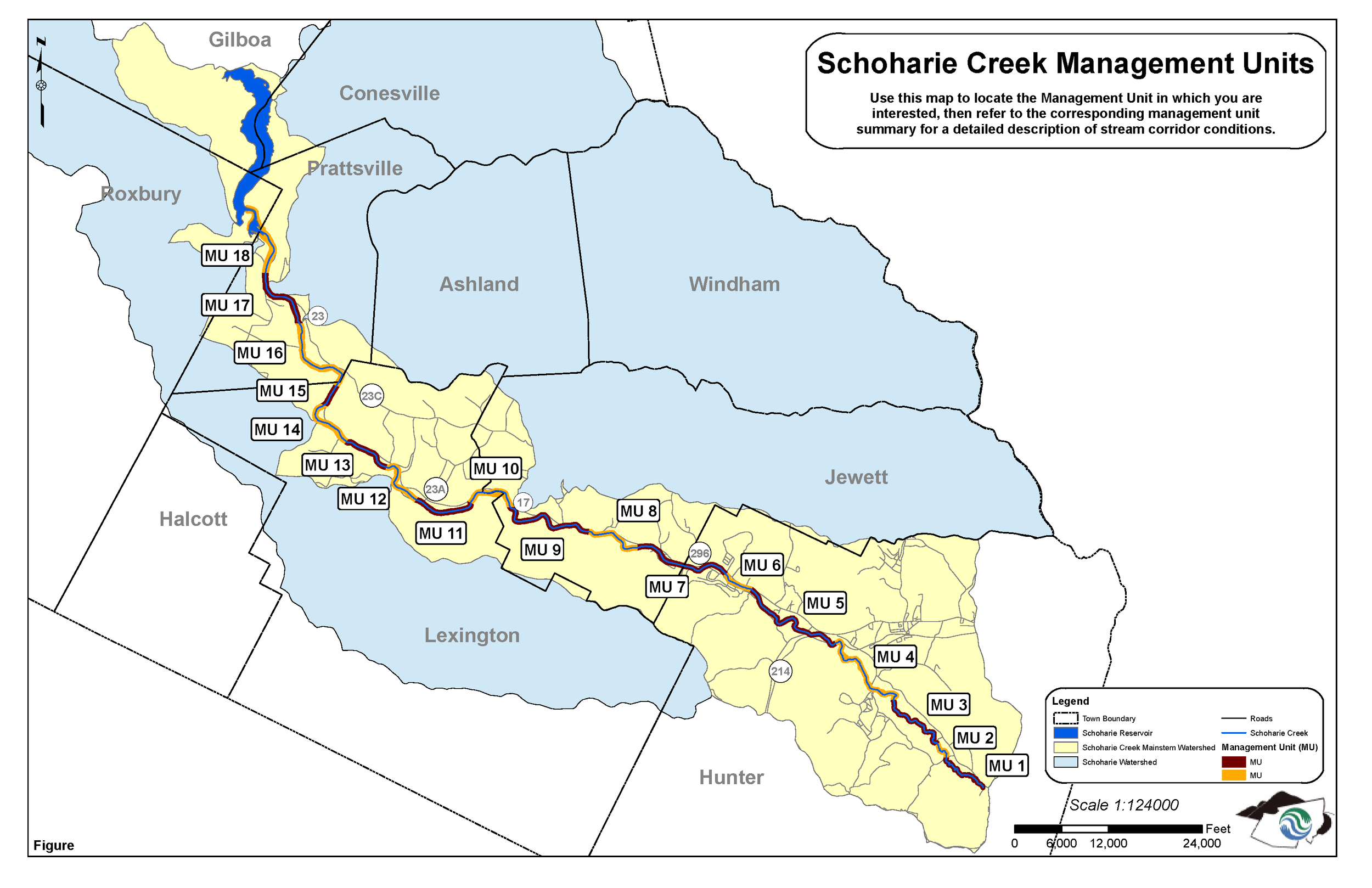
This section contains very detailed descriptions and specific recommendations for the Schoharie Creek, from the headwaters at the top of the watershed, downstream to its confluence with Schoharie Reservoir, located in the Town of Prattsville. The Schoharie Creek mainstem has been organized into 18 Management Units (MUs), defined using physical stream characteristics, historical channel alignments, location of bridges and road infrastructure, and valley characteristics (Fig. 4.0.1). These MU descriptions outline stream conditions (its bed and banks), general streamside (riparian) vegetation condition, and proximity and arrangement of roads, bridges and culverts.
Appendices
Section 5: Demonstration Projects
Project Reporting from Completion of Proposals, 2007-2009
Section 6: General Recommendations
This section sets forth an extensive list of recommendations related to education and outreach, flood protection, water quality, public enjoyment, fisheries, riparian zone management, stream management, and programmatic issues, providing a frame work for watershed stakeholders to develop a long-term management strategy to protect and improve the Schoharie Creek.
East Kill Management Plan
Section 1: Table of Contents, Preface and Acknowledgements | Introduction & Goals
Section 3: Watershed Inventory and Assessment
Section 4: Management Unit Descriptions
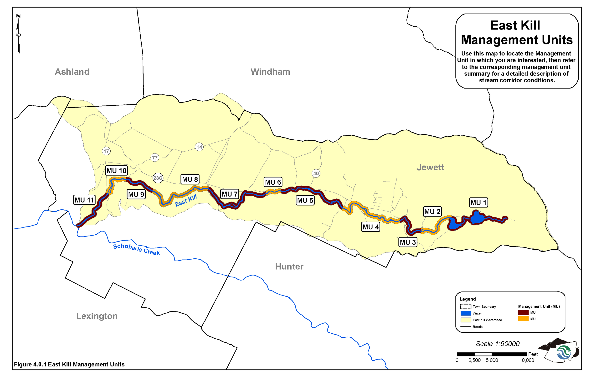
This section offers detailed descriptions and specific recommendations for approximately 16 miles East Kill, from the headwaters upstream from Colgate Lake in Jewett downstream to its confluence with the Schoharie Creek near the County Route 17/23A intersection. This section provides a useful reference for the extent of current problems at a localized stream reach scale, with specific recommendations for action and references to other sections of the plan where further information or resources can be found.
Section 6: General Recommendations
Appendices
The East Kill Management Plan was designed as a comprehensive review of stream characteristics, data, maps and presents recommended management strategies. The management strategies consist of measures that can be taken individually and collectively to reduce the flood risks associated with living in the East Kill Watershed, improve the ecology of the stream and floodplain, while protecting the stream’s many resource values. Ultimately, the plan is meant to assist watershed municipalities and residents in planning for a sustainable future for their property, infrastructure, water and biological resources. Ensuring the health of the watershed’s environmental resources will also help to secure a future of prosperous economic growth and a good quality of life for watershed residents.
West Kill Management Plan
Section 1: Table of Contents, Preface and Acknowledgements| Introduction & Goals
Section 2: Natural and Institutional Resources
Section 3: Watershed Inventory and Assessment
Section 4: Management Unit Descriptions
This section contains very detailed descriptions and specific recommendations for the West Kill, from the headwaters at the top of the watershed, downstream to its confluence with the Schoharie Creek, located in the Town of Lexington. The West Kill mainstem has been organized into 21 Management Units (MUs), defined using physical stream characteristics, historical channel alignments, location of bridges and road infrastructure, and valley characteristics. These MU descriptions outline stream conditions (its bed and banks), general streamside (riparian) vegetation condition, and proximity and arrangement of roads, bridges and culverts.
Email streammanagement@dep.nyc.gov for a copy.
Section 5: Demonstration Projects
Section 6: General Recommendations
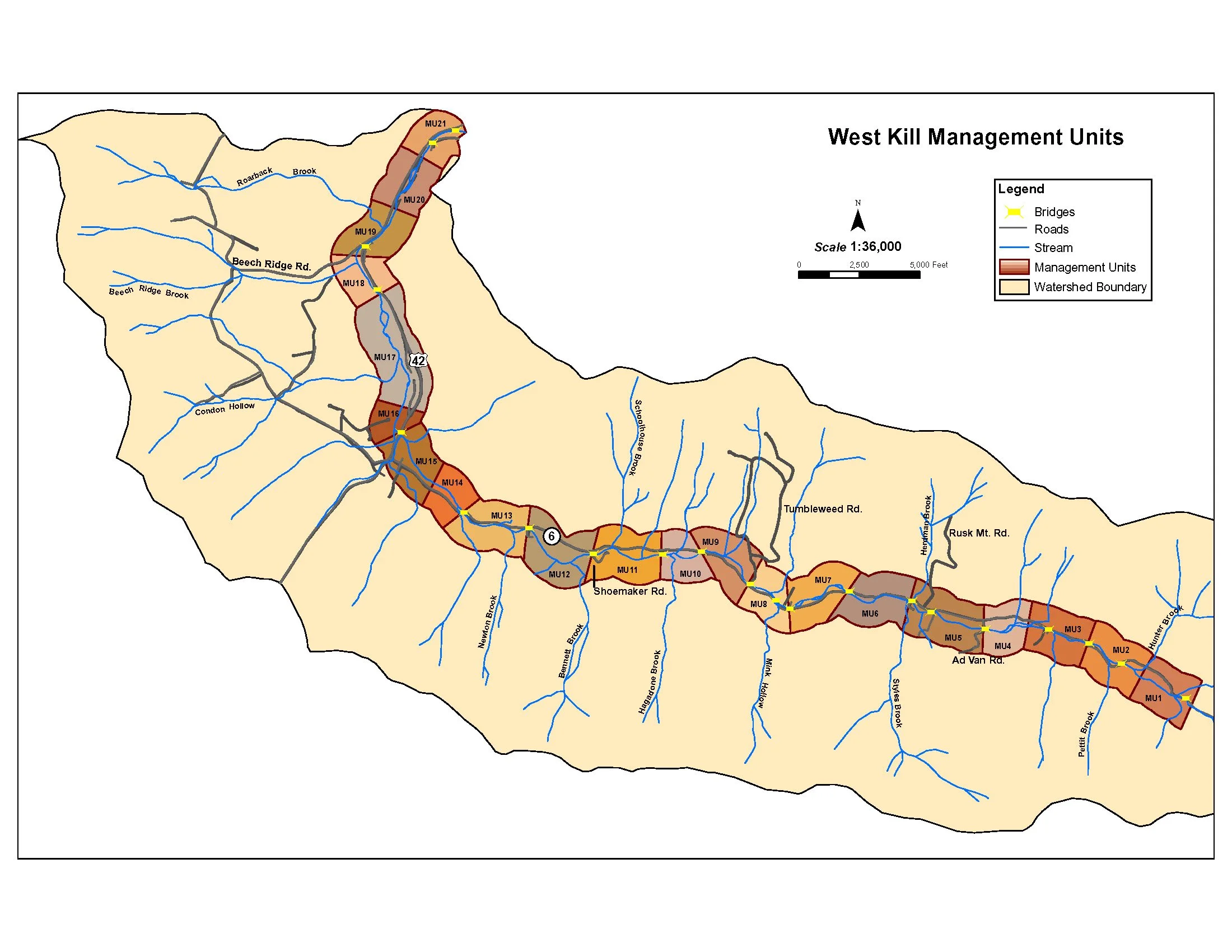
A sub-basin of the Schoharie Creek, the West Kill is located in the southwest section of Greene County in the Town of Lexington with its origin on the southwest slopes of Hunter Mountain (4000′). The stream is approximately 11 miles long, with a contributing drainage area of 59 square miles. The West Kill Stream has a reputation as a productive wild trout fishery. The West Kill has benefited from cold, groundwater contributions and a fairly good riparian zone which shades the stream. The West Kills fishery was a favorite spot of noted angler and author Art Flick, who made it the subject of his writings. The West Kill Valley also has a long history of damaging floods. From a flood event in 1927 which wiped out every bridge in Spruceton Valley, to more recent events in 1996 & 99 which resulted in significant instability in the stream corridor and over 5 million dollars in damages to public infrastructure.
On December 31, 2005, the GCSWCD and NYCDEP-SMP completed the first draft of the West Kill Stream Management Plan which was presented to the USEPA as a component of the City’s watershed protection program. The SMP represents the most detailed assessment of the streams physical condition that has ever been completed, and it is backed by several years of field collected data as well as extensive research and analysis of many factors which may influence stream stability.
Batavia Kill Management Plan
Section 1: Introduction & Goals
Section 2: Natural and Institutional Resources
Section 3: Watershed Inventory and Assessment
Section 4: Management Unit Descriptions
This section contains very detailed descriptions and specific recommendations for the Batavia Kill, from the headwaters at the top of the watershed, downstream to its confluence with the Schoharie Creek, located in the Town of Prattsville. The Batavia Kill mainstem has been organized into 5 Management Units (MUs), defined using physical stream characteristics, historical channel alignments, location of bridges and road infrastructure, and valley characteristics.
Section 5: Demonstration Projects
Section 6: General Recommendations
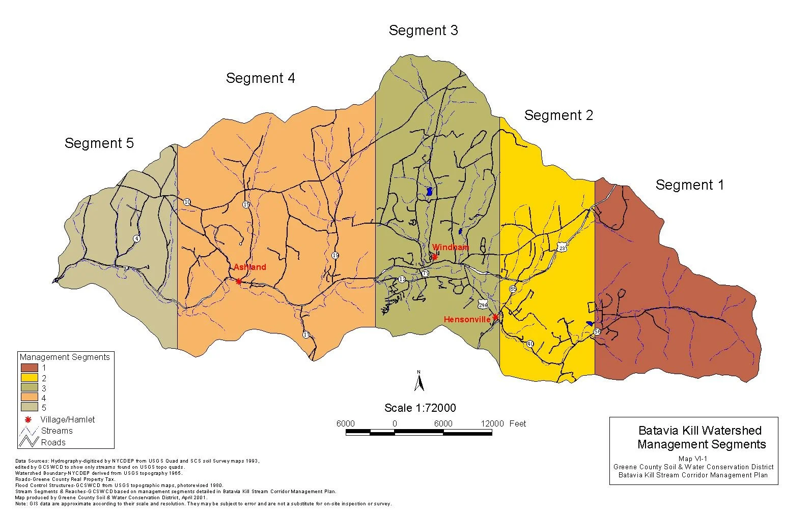
Project the Batavia Kill Stream Management Plan (SMP) was developed after 4 years of watershed and stream corridor assessment in the Batavia Kill watershed. Since 1997, the GCSWCD and NYCDEP have been assessing watershed conditions, monitoring stream stability and undertaking demonstration restoration projects. Based on the data collected and input from various watershed stakeholders, the GCSWCD and NYCDEP completed the Batavia Kill SMP in 2003.
Manor Kill Management Plan
Section 1: Introduction & Goals
Section 2: Natural and Institutional Resources
Section 3: Watershed Inventory and Assessment
Section 4: Management Unit Descriptions
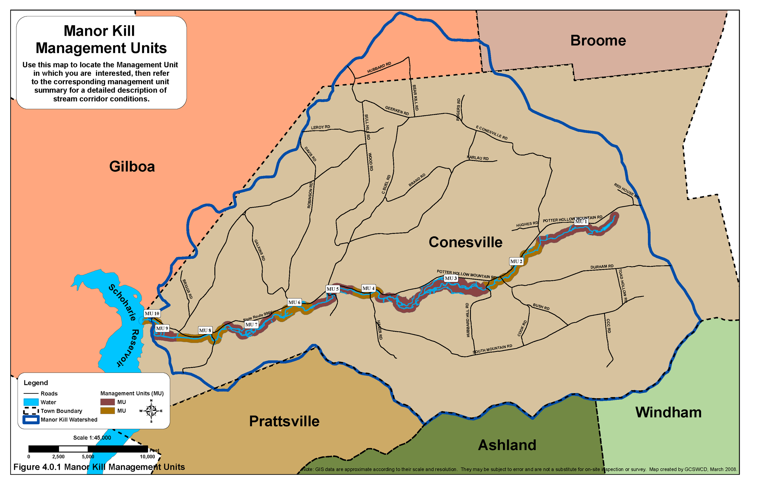
This section contains very detailed descriptions and specific recommendations for the Manor Kill, from the headwaters at the top of the watershed, downstream to its confluence with Schoharie Reservoir, located in the Town of Conesville. The Manor Kill mainstem has been organized into 10 Management Units (MUs), defined using physical stream characteristics, historical channel alignments, location of bridges and road infrastructure, and valley characteristics.
Appendices