NAVIGATIONDCSWCD
PROJECT MAP
SMIP
STREAM GAGES
West & East Branch Delaware River
The West Branch Delaware River and its tributaries are the source waters for the Cannonsville Reservoir, part of the Catskill/Delaware drinking water supply system for the New York City water supply system operated by NYC Department of Environmental Protection (DEP). The watershed above the Cannonsville Reservoir encompasses an area of 353 square miles with approximately 662 total stream miles. The East Branch of the Delaware River is located principally in Delaware County on the eastern portion of the Allegheny Plateau physiographic province. The upper portions of the East Branch, with its eight tributaries, contribute water to the Pepacton Reservoir. The total drainage area of the East Branch Delaware River watershed above the reservoir is 371 square miles with approximately 644.4 total stream miles.
Delaware County Soil & Water Conservation District
Delaware County Soil and Water Conservation District’s (DCSWCD) Stream Management Program (Stream Program) is a partnership formed between the DCSWCD and the NYC Department of Environmental Protection (DEP). Delaware County hosts two NYC drinking water supply systems which are part of the largest unfiltered water supply in the United States. In order to protect this irreplaceable natural resource, the United States Environmental Protection Agency requires NYC DEP to develop comprehensive and innovative watershed protection programs as part of their requirement of the 1997 Memorandum of Agreement (MOA) and Filtration Avoidance Determination (FAD).
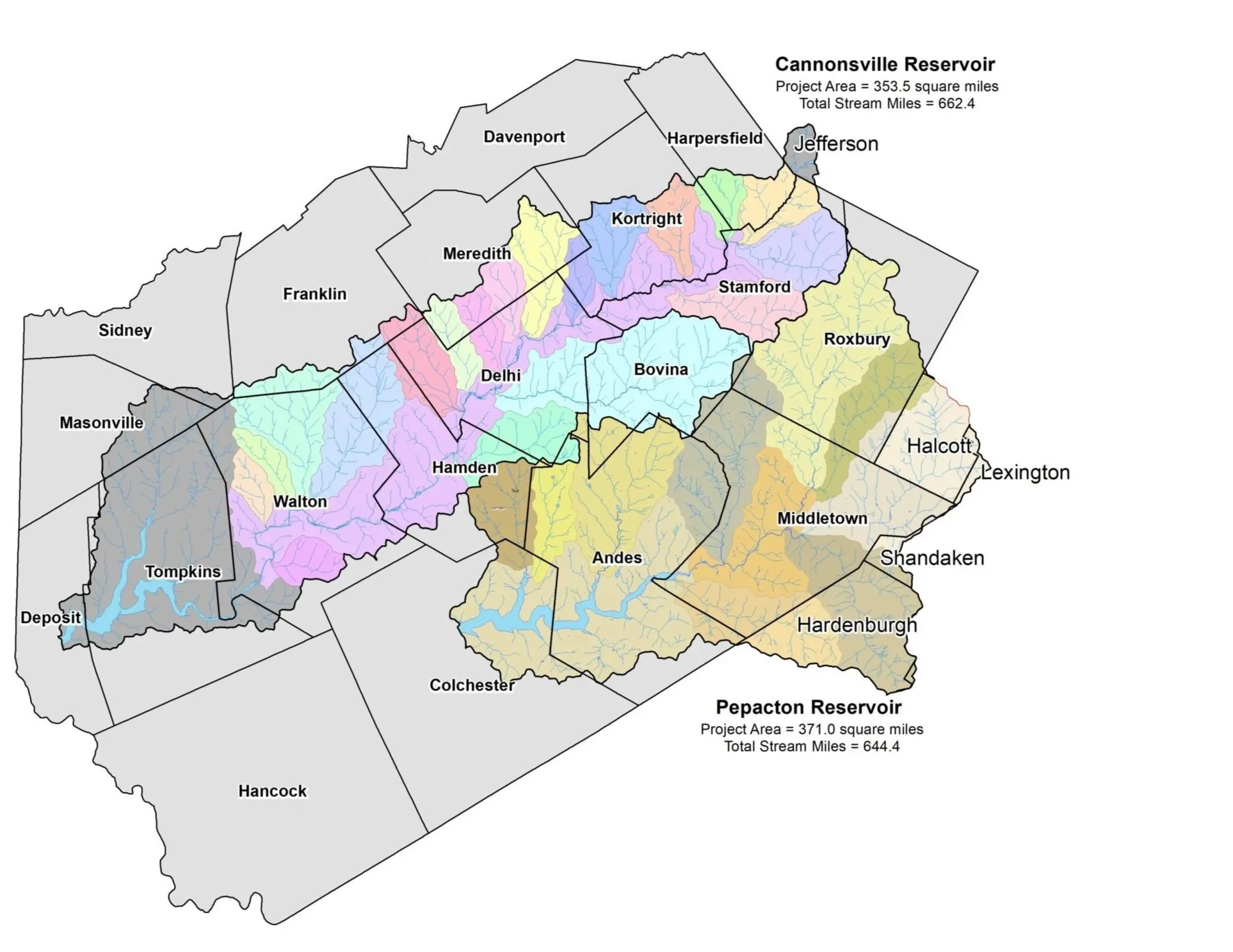
map credit: https://www.delawarecountystreams.org/
Stream Management
-
Delaware County SWCD • Jeff Russel: 607-865-5223
NYC DEP Stream Management • Dave Burns: 845-340-7850
Delaware County Planning • Shelly Johnson: 607-746-2944
Watershed Agricultural Council • Ryan Naatz: 607-865-7790
Click here for Delaware Riverkeeper -
Streams Management Plans provide a comprehensive review of stream characteristics, data, maps and recommended management strategies.
Management strategies consist of measures to individually and collectively reduce the risks of living along Catskill streams, improve the ecology of the stream and floodplain, while protecting the stream’s many resources values.
Ultimately, the plans are meant to assist watershed municipalities and residents in planning for a sustainable future for their property, infrastructure, water and biological resources. Ensuring the health of the watershed’s environmental resources will also help to secure a future of prosperous economic growth and a good quality of life for watershed residents.
WB Stream Management Plan
EB Stream Management Plan
-
Delaware Watershed Advisory Committee
The Delaware Watershed Advisory Committee allows for collaboration on watershed efforts that benefit both water quality and the watershed communities. Watershed towns within Delaware County have adopted Stream Management Plans and Stream Stewardship Principles, signed Memoranda of Understanding with the Delaware County Soil & Water Conservation District and have assigned representatives to the Delaware Watershed Advisory Committee.
Delaware Basin Project Advisory Committee Membership
The Project Advisory Committee (PAC) was formed to help empower local communities to take ownership of stream management on the local level. PAC role is to be leader in the SCMP implementation of the recommendations, identify local needs, and work with the communities and resource agencies toward solutions and project implementation. The PAC assists the Stream Corridor Management Program Team in the further development and implementation of the Biennial Action Plans, review and scores on the Delaware Watershed Stream Management Grant Program and is a liaison with watershed stakeholders. Members also serve on one of the four Sub-committees: Fisheries and Habitat, Flood Issues, Highway and Infrastructure and Education and Outreach. For more information, contact Delaware County Soil and Water Conservation District.
-
Throughout the development, adoption and implementation of these plans there are many opportunities for public involvement.
These include: attending public meetings, participating in focus group discussions, becoming familiar with plan contents, assisting on working groups, participating in workshops and activities like stream clean-ups or streamside plantings, supporting town adoption of stream management plans, and communicating interest in implementing plan recommendation.
-
Action Plan to Guide Stream Management Plan Implementation in the WB & EB Delaware Watershed, 2023-2025
Action Plan to Guide Stream Management Plan Implementation in the WB & EB Delaware Watershed, 2022-2024
-
WB Delaware Studies
EB Delaware Studies
Click on the links below for the USGS Four-part Series: Hydrogeology and Water Quality of the Pepacton Reservoir Watershed in Southeastern New York
-
Delaware County Community Mapping Tool: https://spatial.vhb.com/comit/
Delaware County All Hazard Mitigation Plan: https://delaware.mitigateny.org/
Stream Management Plan Implementation Funding
The Delaware Watershed Stream Management Grant Program offers assistance to local communities, residents, and organizations to advance recommendations from the East and West Branch Delaware River Stream Corridor Management Plans. Categories of funding include: Flood Management, Highway and Infrastructure Improvement, Stormwater Implementation and/or Critical Area Seedling, Recreation-Based Opportunities or Habitat Enhancements, General Restoration Projects, Education/Outreach/Training, on Watershed Protection, and Planning & Assessment.
Project Maps
West Branch Project Map
East Branch Project Map
Stream projects are one component of the NYCDEP SMP). The primary goals of stream management projects include water quality improvement through the reduction of bed or bank erosion and the associated turbidity and other pollutants, infrastructure and/or property protection (flood hazard mitigation), aquatic habitat enhancement and riparian restoration and/or protection. These locally based demonstration projects support the education and training component of the SMP. Natural channel design principles are incorporated wherever possible into projects to ensure multiple benefits are achieved.
Project Maps provide information on a selection of full channel stream restoration, stormwater and infrastructure, riparian buffer restoration, streambank stabilization, and floodplain restoration projects that have been constructed to meet multiple objectives including: infrastructure protection, improved flood conveyance and sediment transport, improved fish habitat, and improved riparian functions.
United States Geological Survey (USGS) Stream Gages
The United States Geological Survey (USGS) maintains 11 continuous-recording stream gages in the West Branch Delaware River watershed above the Reservoir and seven continuous-recording stream gages in the East Branch. These gages measure the stage, or height, of the water surface at a specific location, updating the measurement every 15 minutes. Click on the Station ID number of your gage of interest to receive real-time water surface data from USGS.
West Branch Delaware River
| Station ID | Station Name | Drainage Area (Mi) | Current Period of Record |
| 1421610 | WEST BRANCH DELAWARE RIVER AT HOBART | 15.5 | Aug 2000 – present |
| 1421618 | TOWN BROOK SOUTHEAST OF HOBART | 14.3 | Oct 1997 – present |
| 1421900 | WEST BRANCH DELAWARE RIVER UPSTREAM FROM DELHI | 134 | Dec 1996 – present |
| 1422500 | LITTLE DELAWARE RIVER NEAR DELHI | 49.8 | Jan 1997 – present |
| 1422747 | EAST BROOK EAST OF WALTON | 24.7 | Oct 1998 – present |
| 1423000 | WEST BRANCH DELAWARE RIVER AT WALTON | 332 | Oct 1950 – present |
| 142400103 | TROUT CREEK NEAR TROUT CREEK | 20.2 | Dec 1996 – present |
| 1422779 | WEST BROOK AT AUSTIN LINCOLN PARK AT WALTON | 22.3 | Dec 2017 – present |
East Branch Delaware River
| Station ID | Station Name | Drainage Area (Mi) | Current Period of Record |
| 1413088 | EAST BRANCH DELAWARE RIVER AT ROXBURY | 13.5 | June 2000 – present |
| 1413398 | BUSH KILL NEAR ARKVILLE NY | 46.7 | Oct 1997 – present |
| 1413408 | DRY BROOK AT ARKVILLE NY | 82.2 | Dec 1996 – present |
| 1413500 | EAST BRANCH AT MARGARETVILLE NY | 163 | Feb 1937 – present |
| 1414000 | PLATTE KILL AT DUNRAVEN NY | 34.9 | Oct 1941 – Sept 1962, Dec 1996 – present |
| 1414500 | MILL BROOK NEAR DUNRAVEN NY | 25.2 | Feb 1937 – present |
| 1415000 | TREMPER KILL NEAR ANDES NY | 33.2 | Feb 1937 – present |