Rondout Creek
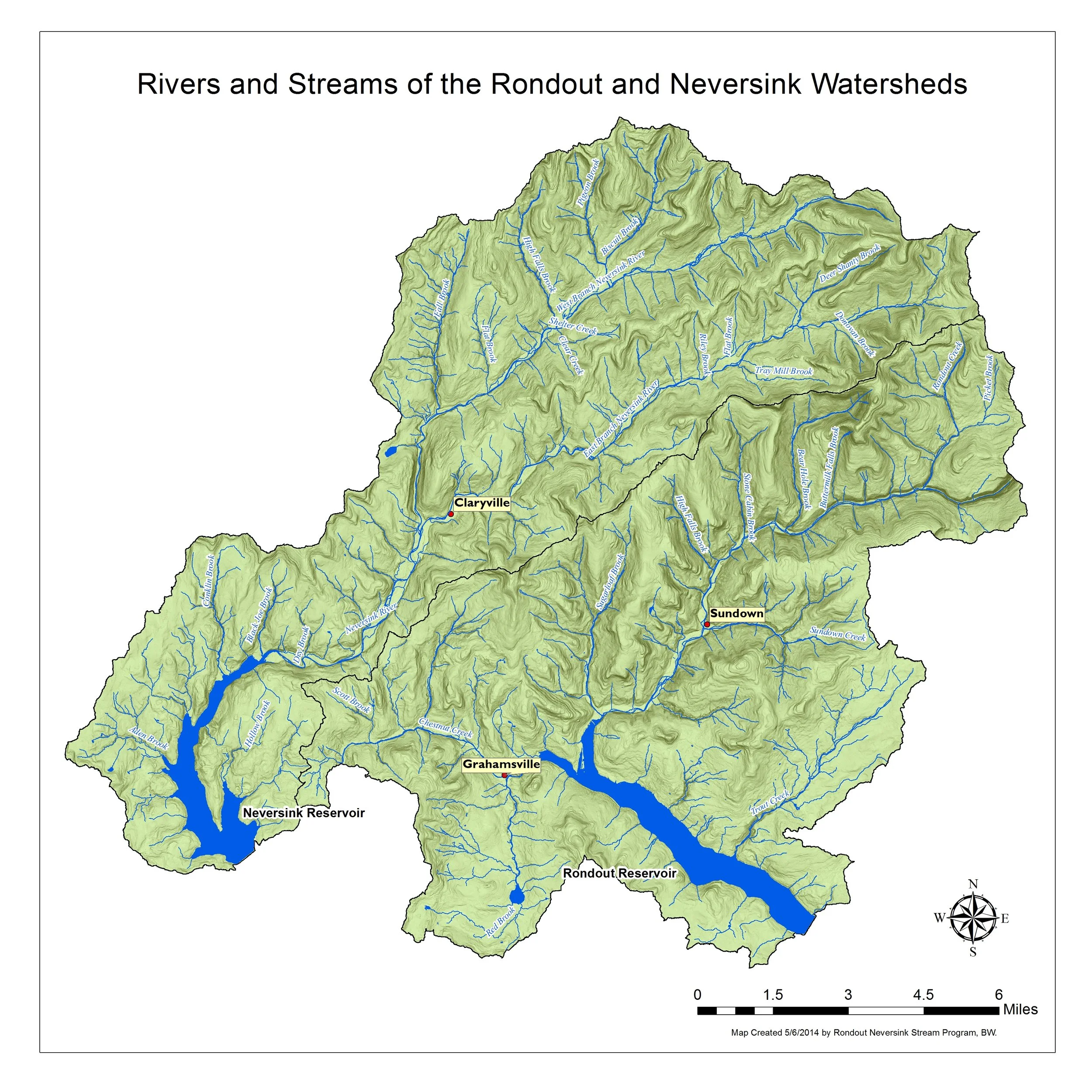
Encompassing approximately 95 square miles, the Rondout Reservoir watershed, is located primarily in Sullivan and Ulster County, NY. The Rondout Reservoir watershed drains mainly two towns – Denning in Ulster County and Neversink in Sullivan County. Small portions of Rochester, Wawarsing, Shandaken and Olive (Ulster) and Fallsburg (Sullivan) are also within the reservoir watershed. The lowest elevation within the watershed is 840 ft at the reservoir and the highest point is near the headwaters of the Rondout Creek at 3,837 ft. The primary tributaries that drain into the Rondout Reservoir are the Chestnut Creek, Trout Creek, Red Brook, Sugarloaf Brook and Rondout Creek. Streams in the Rondout valley are primarily perennial streams, that is, they flow year-round except in smaller headwater streams or in rare, extreme drought conditions.
Neversink River
Encompassing approximately 93 square miles, the Neversink Reservoir watershed is located in Ulster and Sullivan Counties, NY. The Neversink River, including both its East and West Branches, drains 71 square miles. 22 square miles drain directly into the Neversink Reservoir through two dozen small tributaries. The Neversink watershed lies predominantly in the Towns of Denning and Neversink, with a small portion of its headwaters in the Town of Shandaken, and very small portions of the Towns of Liberty and Fallsburg draining directly into the reservoir. The mainstem divides approximately 8.7 kilometers (5.4 miles) upstream of the Neversink Reservoir into two major Branches: East and West. All three of these mainstems have long narrow watersheds running northeast to southwest. This drainage pattern is controlled by steep topography, formed in large part during the last period of glacial activity.
Rondout Neversink Stream Program
The Rondout Neversink Stream Program (RNSP) was established in a partnership among Ulster and Sullivan County Soil & Water Conservation Districts (UCSWCD & SCSWCD) and NYC Department of Environmental Protection (DEP) in 2009 as part of the Filtration Avoidance Determination (FAD) issue to DEP by the Environmental Protection Agency. RNSP supports the Towns of Denning and Neversink watersheds in protecting and restoring water quality through improved stream stability, enhanced aquatic and riparian ecosystems and reduced flooding and erosion hazards.
● Information
Stream Management
-
RNSP • Stacie Howell: 845-985-2581
NYC DEP Stream Management • Dave Burns: 845-340-7850 -
Streams Management Plans provide a comprehensive review of stream characteristics, data, maps and recommended management strategies.
Management strategies consist of measures to individually and collectively reduce the risks of living along Catskill streams, improve the ecology of the stream and floodplain, while protecting the stream’s many resources values.
Ultimately, the plans are meant to assist watershed municipalities and residents in planning for a sustainable future for their property, infrastructure, water and biological resources. Ensuring the health of the watershed’s environmental resources will also help to secure a future of prosperous economic growth and a good quality of life for watershed residents.
Rondout Watershed:
Neversink Watershed
-
Throughout the development, adoption and implementation of these plans there are many opportunities for public involvement.
These include: attending public meetings, participating in focus group discussions, becoming familiar with plan contents, assisting on working groups, participating in workshops and activities like stream clean-ups or streamside plantings, supporting town adoption of stream management plans, and communicating interest in implementing plan recommendation.
-
-
Resources & Documents:
Rondout Studies:
Rondout Demonstration Projects
Project Maps
Rondout & Neversink Watershed Project Map
Stream projects are one component of the NYCDEP SMP). The primary goals of stream management projects include water quality improvement through the reduction of bed or bank erosion and the associated turbidity and other pollutants, infrastructure and/or property protection (flood hazard mitigation), aquatic habitat enhancement and riparian restoration and/or protection. These locally based demonstration projects support the education and training component of the SMP. Natural channel design principles are incorporated wherever possible into projects to ensure multiple benefits are achieved.
Project Maps provide information on a selection of full channel stream restoration, stormwater and infrastructure, riparian buffer restoration, streambank stabilization, and floodplain restoration projects that have been constructed to meet multiple objectives including: infrastructure protection, improved flood conveyance and sediment transport, improved fish habitat, and improved riparian functions.
Rondout Neversink Stream Management Plan Implementation Funding
EDUCATION & OUTREACH GRANTS APPLICATIONS
Funding is in place to support the Towns of Denning and Neversink, residents, educators, students, community organizations and scientists - the many stakeholders in the health of our streams and rivers. Eligible projects to improve water quality and education about stream stewardship practices include: erosion control, floodplain management, stormwater BMPs, stream crossings, roadside ditch maintenance, training/workshops, public presentations, and school/organization partnerships.
This Is A ROLLING APPLICATION:
Education & Outreach Grant Application Instructions | Education & Outreach Grant Application
Grants will be considered for projects in the categories below as related to water quality stewardship principles including: water quality enhancement/improvement, stream stability and sediment transport improvement, flood hazard mitigation and infrastructure protection, riparian habitat improvement, general ecology, and any educational goal with public benefits to the community consistent with principles and best management practices recommended in the Rondout or Neversink Stream Management Plans.
Training/Workshops; Exhibits and Public Presentations; School Programs; Educational Media in all formats
Assistance available to applicants by email at showell@rondoutneversink.org or phone: 845-985-2581. You may submit completed application forms to showell@rondoutneversink.org.
INFRASTRUCTURE GRANT APPLICATIONS
ELIGIBLE: Town of Neversink, Town of Denning, Ulster & Sullivan Counties in Neversink & Denning
Project Designs/Construction Plans (Sullivan County Soil & Water Conservation District provides P.E. Services)
Emergency Flood Response; Erosion Control; Basin-wide Culvert Inventory; Infrastructure Protection/Floodplain Management; Stormwater BMPs (culverts) or Stream Crossings (bridges); Roadside Ditch Maintenance/Critical Area Seeding
Assistance available to applicants by email at bwagner@rondoutneversink.org or phone: 845-985-2581.
United States Geological Survey (USGS) Stream Gages
Click on the Station ID number of your gage of interest to receive real-time water surface data from USGS.
Rondout Creek
| Station ID | Station Name | Drainage Area (Mi) | Current Period of Record |
|---|---|---|---|
| ABOVE | |||
| 01364959 | RONDOUT CREEK near RED BROOK @ PEEKAMOOSE |
5.36
|
May 1996 – present |
| 01365000 | RONDOUT CREEK near LOWES CORNERS |
38.3
|
Feb 1937 – present |
| 01365500 | CHESTNUT CREEK @ GRAHAMSVILLE |
20.9
|
Oct 1988 – present |
| BELOW | |||
| 0136230002 | RONDOUT CREEK @ ROSENDALE | 383 | Aug 1926 – present |
| 01362342 | WALLKILL RIVER @ GARDINER | 695 | Sep 1924 – present |
Neversink River
| Station ID | Station Name | Drainage Area (Mi) | Current Period of Record |
|---|---|---|---|
| 0143400680 | EAST BRANCH NEVERSINK RIVER, NORTHEAST OF DENNING |
8.93
|
Oct 1990 – present |
| 01434017 | EAST BRANCH NEVERSINK RIVER near CLARYVILLE |
22.9
|
Feb 1937 – present |
| 01434021 | WEST BRANCH NEVERSINK RIVER @WINNISOOK L NR FROST VALLEY |
0.77
|
Jan 1991 – present |
| 01434025 | BISCUIT BROO ABOVE PIGEON BK @ FROST VALLEY | 3.72 | Jun 1983 – present |
| 01434498 | WEST BRANCH NEVERSINK RIVER @ CLARYVILLE | 33.8 | Jul 1991 – present |
| 01435000 | NEVERSINK RIVER near CLARYVILLE | 66.6 | Jul 1951 – present |