|
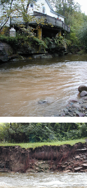
As their name implies, floodplains are subject to periodic flooding.
When there is a flood,healthy floodplains provide storage areas
for flood waters, reduce flood velocities and reduce flood peaks.
A properly functioning floodplain can also provide other benefits
like filtering pollutants and wastes. It can help to moderate
temperature, and provides vital habitat. A stream can be disconnected
from its floodplain by filling and developing the floodplain or
digging in the stream channel. Once disconnected, instability
and erosion throughout the stream system can result. It is typically
recommended to avoid building structures in the 100-year floodplain-the
area which has a 1% chance of being inundated in any given year.
Remember, anything in the floodplain (including buildings) is
at risk of being washed downstream. Visit your town clerk’s
office to learn whether or not your house or any structures on
your property are built within the 100-year floodplain.
Click
here for suggestions for floodplain management
Contact Information & Links
FEMA and their Regional Environmental Officer:
Robert J. Tranter
Phone (212) 680-3628
1-800-621-3362 for individuals who are eligible for Individual
Assistance post flood
USDA/NRCS service centers:
Ulster County
HIGHLAND SERVICE CENTER
652 STATE ROUTE 299
HIGHLAND, NY 12528-2926
(845) 883-7162
(845) 883-7184 fax
Greene County
JOHNSTOWN SERVICE CENTER
113 HALES MILLS RD
JOHNSTOWN, NY 12095-9742
(518) 762-0077
(518) 762-7020 fax
GHENT SERVICE CENTER
1024 RT 66
GHENT, NY 12075-3200
(518) 828-4385
(518) 828-0166 fax
Delaware County
WALTON SERVICE CENTER
44 WEST ST
WALTON, NY 13856-1041
(607) 865-4005
(607) 865-7465 fax
Sullivan County
LIBERTY SERVICE CENTER
64 FERNDALE-LOOMIS RD
LIBERTY, NY 12754-2902
(845) 292-6471
(845) 292-2180 fax
Links and Resources
Click on the links below for more information:
|
|