|
Introduction
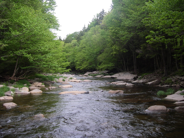
Encompassing approximately 315 square miles, the Schoharie Reservoir watershed, is located primarily in Greene County, NY. The Schoharie Creek drains eight Greene County municipalities, not including direct drainage to the reservoir, including large sections of the Towns of Prattsville, Lexington, Jewett, Hunter, Ashland, Windham and the Villages of Hunter and Tannersville. Traveling from east (Hunter) to west (Prattsville), the primary tributaries that drain into the Schoharie Creek are the East Kill, West Kill, Little West Kill, Batavia Kill, Huntersfield Creek, Johnson Hollow Brook, and directly into the reservoir the Bear Kill and Manor Kill. The major streams within the Schoharie watershed tend to have long, narrow watersheds running east to west. This drainage pattern is controlled by the steep topography, formed in large part during the last period of glacial activity. Streams in the Schoharie valley are primarily perennial streams, that is, they flow year-round except in smaller headwater streams or in extreme drought conditions.
In order to meet both surface and groundwater needs, both quality and quantity, it was determined that a comprehensive watershed approach was required to document the magnitude of potential impairments, and involve watershed stakeholders in recommending strategies for remediation and management. To this end, the Greene County Soil and Water Conservation District (GCSWCD) and New York City Department of Environmental Protection (NYCDEP) have conducted extensive watershed assessments, authored four management plans for the various major basins and have embarked on an extensive restoration and outreach campaign.
Maps
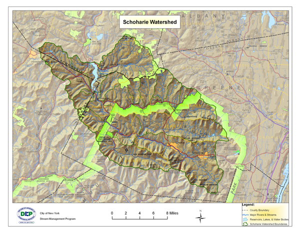
Click here for a larger view of the above map
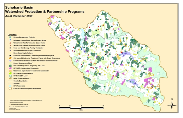
Click here for a larger view of the above map
Click on the links below for more maps:
Batavia Kill Fishing Easement Map
East Kill – Fishing Easement Map
East Kill Parks and Preserves Map
Schoharie Creek Parks and Preserves Map
Schoharie Basin Recreation Map
Schoharie Creek Fishing Easement Map
West Kill Fishing Easement Map
Schoharie Watershed Advisory Committee (Click Here)
This page summarizes the activities of the SWAC, and provides the background information and application materials for the Schoharie Watershed Stream Management Plan Implementation Program.
USGS Gage Links
Click here for The United States Geological Survey
The United States Geological Survey (USGS) maintains 12 continuous-recording stream gages in the Schoharie Creek watershed above the Reservoir. These gages measure the stage, or height, of the water surface at a specific location, updating the measurement every 15 minutes. Click on the Station ID number of your gage of interest to receive real-time water surface data from USGS.
| Station ID |
Station Name |
Drainage
Area (Mi_) |
Current Period of Record |
| 01349541 |
SUGARLOAF BROOK SOUTH OF TANNERSVILLE NY |
1.12 |
1999 - 2009 |
| 01349700 |
EAST KILL NR JEWETT CENTER NY |
35.6 |
1996 - present |
| 01349705 |
SCHOHARIE CREEK NEAR LEXINGTON NY |
96.8 |
8/99 - present |
| 01349711 |
WEST KILL BELOW HUNTER BROOK NEAR SPRUCETON NY |
4.97 |
10/97 - present |
| 01349810 |
WEST KILL NEAR WEST KILL NY |
27 |
10/97 - present |
| 01349840 |
BATAVIA KILL NEAR MAPLECREST NY |
2.03 |
10/97 - 06/09 |
| 01349950 |
BATAVIA KILL AT RED FALLS NEAR PRATTSVILLE NY |
68.6 |
1997 - present |
| 01350000 |
SCHOHARIE CREEK AT PRATTSVILLE NY |
237 |
10/1902 - present |
| 01350032 |
TOAD HOLLOW BROOK NEAR GRAND GORGE NY |
25.7 |
10/98 - present |
| 01350035 |
BEAR KILL NEAR PRATTSVILLE NY |
25.7 |
10/98 - present |
| 01350080 |
MANOR KILL AT WEST CONESVILLE NEAR GILBOA NY |
32.4 |
7/86 - present |
| 01350101 |
SCHOHARIE CREEK AT GILBOA NY |
316 |
10/75 - present |
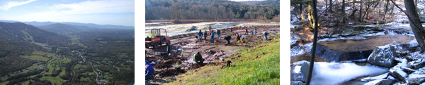
Demonstration Restoration Projects
Click on the following links for more information:
Batavia Kill: Ashland Connector Stream Restoration Project Report (1.5 MB)
Batavia Kill: Brandywine Restoration Project Implementation and Monitoring Report (4.4 MB)
Batavia Kill: Maier Farm Restoration Project Implementation and Monitoring Report (4.5 MB)
Batavia Kill: Conine Stream Restoration Project Report (7 MBs)
West Kill: R.A. Hill Stables Demonstration Project Report (2.09 MB)
West Kill: Westkill Stream Restoration Demonstration Project Report
West Kill: Long Road Stream Restoration Project Report
East Kill: East Kill Farber Farm Restoration Project Report
Schoharie Creek: 2007 Proposed Schoharie Projects
Schoharie Creek: County Route 13 Undersized Culvert Replacement (2.5 MB)
Schoharie Creek: Schoharie Creek Embankment Repair at Schoharie Street (1.29 MB)
Schoharie Creek: Carr Road Riparian Restoration (3.4 MB)
Stream Management Plans
Click here for Intro and links to Stream Management Plans
Click on the following links for more information:
Schoharie Creek Stream Management Plan
East Kill Stream Management Plan
West Kill Stream Management Plan
Batavia Kill Stream Management Plan
Batavia Kill: Executive Summary of the Batavia Kill Stream Management Plan
Manor Kill Stream Management Plan
Schoharie Basin Action Plans
Schoharie Basin Stream Management Plan Implementation Action Plan, 2007 – 2009
Schoharie Basin Stream Management Plan Implementation Action Plan, 2009-2011: This three-part package includes: 1. Schoharie Basin Stream Management Plan Implementation Action Plan 2009 – 2011 2. Completed projects synopsis and 3. Progress tracking sheet that will be updated as action items are completed.
Schoharie Basin Stream Management Implementation Action Plan, 2009-2011: May, 2010 Update
Schoharie Basin Stream Management Program Action Plan, 2011– 2013
Schoharie Basin Stream Management Program Action Plan, 2013– 2015
Basin Specific Studies
Effectiveness of Stream Restoration in Reducing Stream Bank Erosion: The Case of Batavia Kill Stream Restoration Projects, New York (Chen, Y. et al., 2005)
Summary of Schoharie Wildlife and Fishery
Greene County All Hazards Mitigation Plan (2009)
Schoharie Creek Fisheries Management Plan (1993)
Contact Information
GCSWCD
Abbe Martin
Project Coordinator
907 County Office Building
Cairo, NY 12413
Phone: (518) 622-3620
Fax: (518) 622-0344
abbe@gcswcd.com |
|
NYCDEP
Dave Burns
Project Manager
71 Smith Ave
Kingston, NY 12491
Phone: (845) 340-7850
Fax: (845) 338-1367
dburns@dep.nyc.gov |
|