|
Introduction
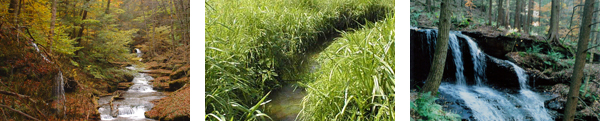
Encompassing approximately 95 square miles, the Rondout Reservoir
watershed, is located primarily in Sullivan and Ulster County,
NY. The Rondout Reservoir watershed drains mainly two towns –
Denning in Ulster County and Neversink in Sullivan County. Small
portions of Rochester, Wawarsing, Shandaken and Olive (Ulster)
and Fallsburg (Sullivan) are also within the reservoir watershed.
The lowest elevation within the watershed is 840 ft at the reservoir
and the highest point is near the headwaters of the Rondout Creek
at 3,837 ft. The primary tributaries that drain into the Rondout
Reservoir are the Chestnut Creek, Trout Creek, Red Brook, Sugarloaf
Brook and Rondout Creek. Streams in the Rondout valley are primarily
perennial streams, that is, they flow year-round except in smaller
headwater streams or in rare, extreme drought conditions.
In order to meet both surface and groundwater needs, both quality
and quantity, it was determined that a comprehensive watershed
approach was required to document the magnitude of potential impairments,
and involve watershed stakeholders in recommending strategies
for remediation and management. To date, the Sullivan County Soil
and Water Conservation District (SCSWCD) and New York City Department
of Environmental Protection (NYCDEP) have completed a stream management
plan for the Chestnut Creek and a demonstration restoration project
behind the Neversink Town Hall. NYCDEP has plans to conduct a
similar study within the Rondout Creek watershed in upcoming years.
Additionally, the nonprofit organization, Hudson River Sloop
Clearwater, received grant money from the Hudson River Estuary
Program to work with communities in the Rondout watershed below
the Reservoir. The goal of the project is to engage community
members in watershed planning. Already various stakeholders have
agreed to participate on a Rondout Watershed Council. Activities
planned for upcoming months include Watershed Awareness Training
and Stream Monitoring Training.
Maps
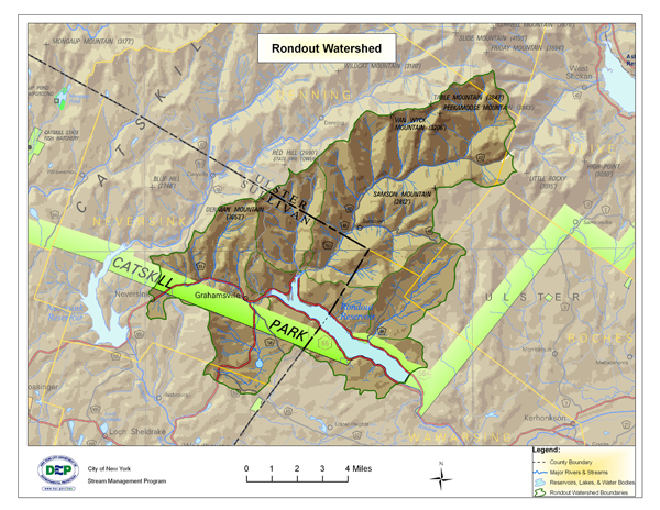
Click
here for a larger view of the above map
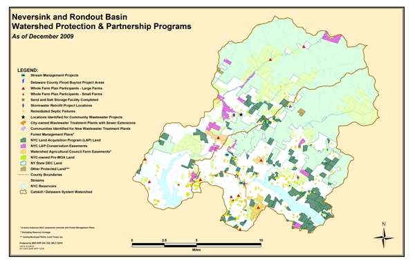
Click
here for a larger view of the above map
USGS Gage Links
The United States Geological Survey (USGS) maintains 5 continuous-recording
stream gages in the Rondout Creek watershed above and below the
Reservoir. These gages measure the stage, or height, of the water
surface at a specific location, updating the measurement every
15 minutes. Click on the Station ID number of your gage of interest
to receive real-time water surface data from USGS.
| Station
ID |
Station
Name |
Drainage
Area (Mi_) |
Current
Period of Record |
| ABOVE |
| 01364959 |
Rondout Creek near Red Brook at Peekamoose |
5.36 |
May 1996 - Sept 2011 |
| 01365000 |
Rondout Creek near Lowes Corners |
38.3 |
Feb 1937 - present |
| 01365500 |
Chesnut Creek at Grahamsville |
20.9 |
Oct 1988 - present |
| BELOW |
| 0136230002 |
Rondout Creek at Rosendale |
383 |
Aug 1926 - present |
| 01362342 |
Wallkill River at Gardiner |
695 |
Sep 1924 - present |
Demonstration Restoration Projects
Chestnut Creek:
Town
Hall Demonstration Site
East Branch Rondout Creek:
Bank StabilizationDemonstration Project at the
Ulster County Highway Garage (21 MB)
Stream Management Plans
Intro and links to Stream Management Plans
Upper Rondout Creek Stream Management Plan Summary (4.3 MB)
Basin Specific Studies and Other Resources
THE SOURCE, February 2012 Newsletter of the Rondout/Neversink Stream Management Program
Spread the Word, Not the Weed: Knotweed Brochure
Managing Large Woody Debris in Sullivan County, NY
Rondout Creek Report Card (NYSDEC and HBRW)
Opinions and Interests Concerning Stream Management Expressed By Streamside Landowners in the Upper Rondout and the East and West Branches of the Neversink River, 2009
Rondout Basin Action Plan(s)
Rondout/Neversink Stream Management Program Action Plan 2010 – 2012
Rondout/Neversink Stream Management Program Action Plan 2013 – 2013
Contact Information
Lower Rondout |
|
Upper Rondout |
Victor-Pierre Melendez
Rondout Creek Watershed Council Coordinator
Hudson River Sloop Clearwater
724 Wolcott Ave.
Beacon, NY 12508
Phone: (845) 845) 265-8080
victor@clearwater.org |
|
Karen Rauter
Stream Program Coordinator
Sullivan County Soil & Water Conservation District
P.O. Box 256, 273 Main Street
Grahamsville, NY 12470
Phone: (845) 985-2581
krauter@rondoutneversink.org |
| |
|
NYCDEP
Mark Vian
Project Manager
71 Smith Ave
Kingston, NY 12491
Phone: (845) 340-7851
Fax: (845) 338-1367
mvian@dep.nyc.gov |
|