Major Streams: East Branch Delaware
River
Introduction
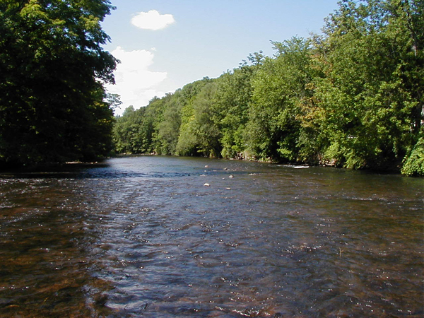
The East Branch of the Delaware River is located principally
in Delaware County on the eastern portion of the Allegheny Plateau
physiographic province. The upper portions of the East Branch
Delaware River with its eight tributaries contribute water to
the Pepacton reservoir, part of the New York City water supply
system operated by NYC Department of Environmental Protection.
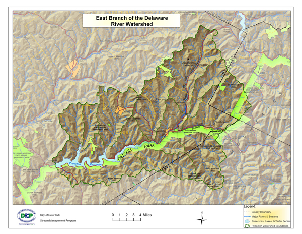
The total drainage area of the East Branch Delaware River watershed
above the reservoir is 371 square miles with 644.4 total stream
miles. The watershed includes land within eleven townships and
three counties. While the majority of the watershed is contained
within Delaware County, sections of the headwaters are found in
the western Catskill mountains of Ulster and Greene County.
Maps
Click
here for a larger view of the above map
Click
here for a larger view of the above map
Delaware Watershed Stream Management Grant Program (Click Here)
The Delaware Watershed Stream Management Grant Program offers assistance to local communities, residents, and organizations to advance recommendations from the East and West Branch Delaware River Stream Corridor Management Plans. Categories of funding include: Flood Management, Highway and Infrastructure Improvement, Stormwater Implementation and/or Critical Area Seedling, Recreation-Based Opportunities or Habitat Enhancements, General Restoration Projects, Education/Outreach/Training, on Watershed Protection, and Planning & Assessment.
USGS Gage Links
The United States Geological Survey (USGS) maintains 7 continuous-recording
stream gages in the East Branch Delaware River watershed above
the Reservoir. These gages measure the stage, or height, of the
water surface at a specific location, updating the measurement
every 15 minutes. Click on the Station ID number of your gage
of interest to receive real-time water surface data from USGS.
| Station
ID |
Station
Name |
Drainage
Area (Mi_) |
Current
Period of Record |
| 01413088 |
East Branch Delaware River at Roxbury |
13.5 |
June 2000 - present |
| 01413398 |
Bush Kill Near Arkville NY |
46.7 |
Oct 1997 - present |
| 01413408 |
Dry Brook at Arkville NY |
82.2 |
Dec 1996 - present |
| 01413500 |
East Branch at Margaretville NY |
163 |
Feb 1937 - present |
| 01414000 |
Platte Kill at Dunraven NY |
34.9 |
Oct 1941 - Sept 1962, Dec 1996 - present |
| 01414500 |
Mill Brook Near Dunraven NY |
25.2 |
Feb 1937 - present |
| 01415000 |
Tremper Kill Near Andes NY |
33.2 |
Feb 1937 - present |
Demonstration Restoration Projects
Projects to be completed Summer 2007. Please check back soon
for more information.
Stream Management Plans
Click
here for Intro and links to Stream Management Plans
Click
here for Watershed Overview
Delaware Basin Action Plan(s)
Action Plan to Guide Stream Management Plan Implementation in the EB Delaware Watershed, 2008-2010
Action Plan to Guide Stream Management Plan Implementation in the EB Delaware Watershed, 2010-2012
Basin Specific Studies
Click on the links below for the USGS Four-part Series
Hydrogeology
and Water Quality of the Pepacton Reservoir Watershed in Southeastern
New York. Part 1. Concentrations of pesticides and their degradates
in stream baseflow, 2000-2001
USGS
Study: Hydrogeology and Water Quality of the Pepacton Reservoir
Watershed in Southeastern New York. Part 2. Hydrogeology, Stream Base
Flow, and Ground-water Recharge
Hydrogeology
and Water Quality of the Pepacton Reservoir Watershed in Southeastern
New York. Part 3. Responses of Stream Base-Flow Chemistry
to Hydrogeologic Factors nd Nonpoint-Sources of Contamination
Hydrogeology
and Water Quality of the Pepacton Reservoir Watershed in Southeastern
New York. Part 4. Quantity and Quality of Ground-Water and
Tributary Contributions to Stream Base Flow in Selected Main-Valley
Reaches
Contact Information
Delaware County SWCD • Rick Weidenbach: (607) 865-7161
NYC DEP Stream Management • Beth Reichheld: (845) 340-7838
Delaware County Planning • Shelly Johnson: (607) 746-2944
Watershed Agricultural Council • Tom O’Brien: (607)
865-7790
Click
here for Delaware Riverkeeper |